Bullitt County Cemetery Index
| Cemetery | Links | Notes |
|---|---|---|
| Achers | Located on Hill Top Road north along Rising Sun Ridge off Hwy44 | |
| Anderson | ||
| Ball | thompson.txt | Also known as the Thompson Cemetery. Located on W. Blue Lick Road near PryorValley Road. |
| Beech Grove | beechgro166gcm.txt | Located on Beech Grove Road |
| Bethel | bethel.txt | Located on Highway 44 between Mt. Washington and Pleasant Grove. |
| Brookland | Located on Hebron Lane, 1/2 mile west of Hwy 61 | |
| Brooks | ||
| Browningtown | browning.txt | Located off Brownington (or Browningtown) Road onSalt Lick Lane on the left next to a small pond. |
| Bullitt Lick | bullick.txt | Located on Hwy 44 about 3 miles from Hwy 31W at the foot of PrayMountain and beside Bullitt Lick Baptist Church. |
| Campground | campground,txt | Located on Martin's Hill behind the JehovahWitness camp on Hwy 44 west |
| Cedar Grove | oldcedarg.txt | Located 5 miles east of I-65 on Hwy 480 at Liver'sLane. |
| cedarg.txt oldcedar.txt | These graves are proven by either obit ordeath certificate as being buried at Old Cedar Grove Cemetery | |
| Chaddic | chaddic.txt | Location: On Chillicoop Road betweenRaymond Road and West Blue Lick Road. This may be one of the oldBlissett or Phelps family Cemeteries. |
| ChappelRidge | chappell.txt | Located on the Fort Knox Military Reservation |
| Collins | ||
| Collings | cem-list.txt | Located on Collings Road in Lebanon Junction, Ky |
| Congrove | ||
| Cundiff | sprinkle.txt | Located on Beech Grove Road about 2 miles from the Lebanon Junctionend of Beech Grove Road. |
| Daugherty | ||
| Dunn | thompson.txt | Alsoknown as the Thompson Cemetery. Located on W. Blue Lick Road near PryorValley Road. |
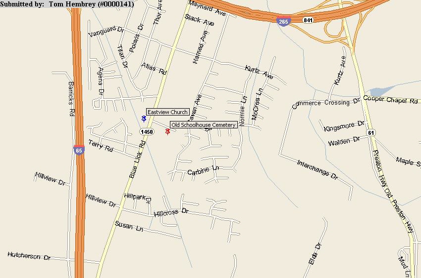
| Eastview Church | eastview.txt | Eastview Church of Christ is located onBlue Lick Road, approximately one quarter mile north of theBullitt/Jefferson County line,in Jefferson County. |
| Fairmont | fairmont.txt | Located in Jefferson County about 2-3 miles north of the BullittCounty Line on Old Bardstown Road. |
| Ferguson | ferguson.txt | Located on top of Brooks Hill approximately 3 miles west ofInterstate 65 interchange. |
| Fort Duffield Burials | ftduffield.txt | Located in Jefferson County, off Hwy 31W, on top of bluffoverlooking West Point, KY and Ohio River. |
| Fort Knox Burials | ftknox.txt | InformationaboutKNOWNBURIALS IN FORT KNOX CEMETERIESin Hardin, Bullitt & Meade Counties |
| Foster | oldfost.txt | Located on Johnson Hollow Road. |
| Froman | ||
| Gentey | ||
| Glenn | ||
| Graham | graham.txt | Located near the intersection of Brooks Hill Rd and Mt. Elmyra Road,on the North side of Brooks Hill Road. |
| Grandell | ||
| Grove | ||
| Hall | oldhall.txt | Cemeterywas located by the old Methodist Church on land donated by John Hall. The churchis no longer in existence, and the headstones have been removed. The church andcemetery was located on what is now Half-Moon Drive in Mt. Washington, KY. |
| Hardy | ||
| Harned | harned.txt | Located on the south side of Wilson Creek Road (State Route 733) atOld Boston Road. |
| Harris | harrisst.txt | Located near Mt. Washington on the Stringer Lane farm. (also calledOld Mothershead Cemetery) |
| Harshfield | harsh.txt | Located at the corner of Yorkshire Blvd. and Hwy 44 West. |
| Hebron | A-E F-L M-R S-Z | Located at intersection of Hwy 61 (Preston Hwy) and Hebron Lane. |
| Highland Memorial Gardens | Located at 31E and Landis Lane in MtWashington | |
| Hoagland | hoagland.txt | Located off Hwy 61 one mile north of Bardstown Junction (or ChapezeLane) |
| Holsclaw | ||
| Horine | horine.txt | Located on Mt Elmira Road 1.5 miles from Brooks Hill Road. |
| Jackson | ||
| John Hall | johnhall.txt | Cemetery is located on Armstrong Lane in Mt Washington, KY on whatwas once known as the Dean Armstrong Farm, but is now a housing projectknown as Helmwood. |
| Johnson | ||
| Jones | ||
| Joyce | ||
| Kings Church | kingschurch.txt kings.txt | Located on Kings Church Road off Hwy 44 East |
| Kinnison | kinnison.txt | Located on Raymond Road on old farm. Private property; permissionrequired for entry. |
| Knob Creek Union | knobcreek.txt knobcree.txt | Located on Highway 44 West in Nichols, KY |
| Lebanon Junction | ||
| Magruder | magruder.txt | Located in Magruder Hollow at Bernheim Forest in Clermont, KY |
| Maraman | maraman.txt | The MARAMAN Cemetery is located on State Route 480 (Cedar Grove Rd)near the I-65 interchange, in the parking lot of The Barnyard store |
| Markwell | markwell.txt | Located one mile from Hwy 44 East off Kings Church Road on MarkwellLane. |
| Martin Hill | martinhi.txt | Located on Martin Lane off Hwy 44 West in Nichols, KY. |
| Masden | wilsoncr.txt | Located on Wilson Creek Road about 1 mile from Hwy 61 near Belmont,KY. |
| McDaniel | ||
| McNutt | ||
| Miller | miller.txt | Located on Beech Grove Road about 1.5 miles from the LebanonJunction end of the road. |
| Monroe | monroe.txt | Located one quarter mile north of Weaver's Run. |
| Mothershead | harrisst.txt | Located near Mt. Washington on the Stringer Lane farm. (also calledHarris Cemetery) |
| Mt Carmel Church - | NameIndex Page mtcarmel.txt | Mt. Carmel Church is located on Mt. CarmelChurch Rd , approximately one and a half miles from SR 733 (Wilson CreekRoad) in Southeast Bullitt County. It is near the Nelson Countyborder. |
| Mt Eden | mteden.txt | Located on Highway 44 West about 7 miles from Shepherdsville. |
| Mt Washington Catholic | mtwashca.txt | Located on US 31E (Old Bardstown Road)adjacent to the Mt. Washington City Cemetery. |
| Mt Washington Memorial | mtwash.txt mtwash-full.txt | Located on old Hwy 44 on the east side oftown |
| Mumford | Located off Horse Fly Hollow Road @ 1 mi.due west of Belmont, KY | |
| Myers | ||
| Newkirk | newkirk.txt | |
| NewSalem | newsalem.txt | Located near the Bullitt and Nelson County line in the Deatsvillearea off Hwy 245. |
| Old Schoolhouse | Located in Jefferson County, KY off Blue Lick Road on privateproperty at end of Old Schoolhouse Road.MAP | |
| Old Shepherdsville City | oldcity.txt | Located beside the city park on W. 1st Street along Salt River. |
| Old Shepherdsville Colored | shepcolor.txt | Located on Highway 44 West in Shepherdsville next to theintersection at Fugate Lane. |
| Owen | owen.txt | Located back in the woods, surrounded by low wire fencing, onprivate property on Greenbriar Road. |
| Pauley | ||
| PendletonHill | pendleton.txt | |
| Perkins | ||
| Phelps | phelps.txt | Located on Fincastle Road in Shepherdsville, KY off Hwy 44 East.Also known as Settler's Gap Cemetery |
| Pleasant Grove | Located on 44 E between Mt. Washington and Shepherdsville at the Pleasant Grove Baptist Church | |
| Quick | quick.txt | Located on New Ed Quick Road 3/4 miles off of Brooks Hill Road onprivate property. |
| Redden | redden.txt | Located off Knob Creek Road on Wierd Road beside the Wierd Cemetery. |
| Ridgeway | ||
| Samuels | samuels.txt | Located on Brooks Hill Road on top of Brooks Hill on privateproperty. |
| Settler's Gap | settlersg.txt | Located on Fincastle Road in Shepherdsville, KY off Hwy 44 East.Also known as PHELPS Cemetery |
| St Francis | oldcath.txt | |
| St Johns | ||
| Shawler | shawler.txt | Located directly across from the main entrance to Camp Crescendonear Lebanon Junction, KY. |
| Shelton | shelton.txt shelton2.txt | Located on a one acre tract east of the old Louisville &Nashville Turnpike and Hwy US 31W and north of the present location ofthe Mill Creek Baptist Church in Radcliff, Hardin County, KY. |
| Shepherd | ||
| Shields | Tombstone photo for Francis Shields | |
| Showalter | ||
| Simmons | simmons.txt | Located on Hwy 480, just east of the I-65 interchange on the southside of the road, up on the hill. |
| Smith | cem-list.txt smith.txt | Located on Knob Creek Road. |
| Snellen | ||
| Stallings | stalling.txt | Located on Owl Creek Court in Lazy River Subdivision inShepherdsville, KY. |
| Swanner | swanner.txt | Located in Lebanon Junction, KY |
| Thompson | thompson.txt | Alsoknown as the Ball or Dunn Cemetery. Located on W. Blue Lick Road nearPryor Valley Road. |
| Tucker | tucker.txt | Located on Hall's Lane in Shepherdsville, KY on the bank of Floyd'sFork where it joins Salt River. |
| Vine Hill | vinehill.txt | Locatedon Happy Hollow Road behind the Jim Beam Distillery off Hwy 245 in Clermont, KY. |
| Weathers | Located on east Hebron lane, north of Camp Shantituck | |
| Wheeler | Located directly across the street from the Burns Cemetery on Beech Grove Road | |
| Weird | cem-list.txt weird.txt | LocatedOn Weird Road off Knob Creek Rd 1 mi west of Barrellton, KY. |
| Woodlawn Memorial Gardens | woodlawn.txt | Located near apartment complex on Blue Lick Road off Hwy 61 inShepherdsville, KY. |
Unnamed Cemetery transcriptions
- SMITH, GILMORE, WALKER, HUBBS, BISHOP - Located on Carrington Ct. which is located approximately 500 yards west of the Cedar Creek Rd and Zoneton Road junction. It is very near the Penn Run/Floyds Fork area, very close to the Jefferson/Bullitt Line.
- Brown, Chappell, Childers, Fowler, Hackworth, McCarthy, Quick, Sanders - Located on Brooks Hill Road on the Chalton Farm owned by Joyce Trammell.
- Brown, Bishop, Kirk - Located on Zoneton Road, just west of the Floyd's Fork housing project.
- Sprinkles, Cundiff, Ice, Peters - Located on Beech Grove Road about 2 miles from the Lebanon Junction end of Beech Grove Road.
- Lee, Cundiff - Located directly across the street from the Burns/ Noe graves on Beech Grove Road
- Burns, Noe - Located on Beech Grove Road, approximately 4 miles from the north (Shepherdsville) junction of Beech Grove Road and Highway 61 on the left side of the road.
- Blissett, Bowman, Chaddic, Parson, Phelps, Sanders, Weyler - We do not know the name of this cemetery. Presumed to be the Blissett, Chaddic or Old Cedar Grove Cemetery. It is located on Chillicoop Road between Raymond Road and West Bluelick Road. There has been several files submitted to this index for this transcription.
- Terry McCauley - The grave sites are located on Blue Lick Road just above the county line in Jefferson County. They are next to the Eastview Church. This does not appear to be a cemetery but rather a plot of several graves. Heavily overgrown and appears to be several more graves.


© 2020. All Rights Reserved. In keeping with our policy of providing free information on the Internet, data may be used by non-commercial entities. These electronic pages may NOT be reproduced in any format for profit or for presentation by other persons or organizations. This site may NOT be linked to or from a pay site. Page last modified: 10 Oct 2020 .